In partnership with the NYS Housing Trust Fund Corporation, Housing Action Council and select municipalities, Habitat for Humanity will coordinate the construction of accessory apartments on the properties of low- to moderate-income residents of Bedford, Dobbs Ferry, Hastings-on-Hudson, Irvington, Cortlandt, Croton-on-Hudson and Yorktown

For additional information please visit Plus One ADU - Habitat NYC and Westchester

Long Island Sound Watershed Program

photo2primary

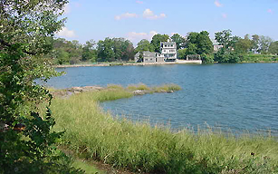
Westchester County's economic, recreational and environmental well-being is directly tied to the health of Long Island Sound, which is designated an Estuary of National Significance. Westchester County also has designated the shore of this estuary a critical environmental area.

In order to protect this resource, county agencies, working with municipalities, have been actively involved in programs to improve water quality and fish and wildlife habitat in the sound's watershed (or drainage basin) in Westchester. Nonpoint source pollution (or polluted stormwater) control is at the heart of these improvement efforts. 

Nonpoint source pollution is polluted stormwater runoff containing sediment, fertilizers and pesticides, petroleum, heavy metals, and wastewater from failing septic systems. These pollutants are often carried by runoff to streams, rivers, and Long Island Sound. They are a serious problem that can only be kept under control by changes in the way we use the land and how we maintain our homes and automobiles.

Watershed Advisory Committees 
The county's nonpoint source pollution control program, initiated in 1991 to  dovetail with the federal and bi-state Long Island Sound Study, has focused its efforts on intermunicipal watershed planning, natural resources restoration and public outreach and education since 1995.

The intermunicipal planning aspect of the program strives to coordinate and guide the activities of 19 cities, town and villages in Westchester’s Long Island Sound watershed, which extends from Lewisboro south to Mount Vernon. To ease this effort, the watershed was separated into seven study areas made up of one to three subwatersheds. A Watershed Advisory Committee (WAC) is assigned to each of the six areas. The WACs are comprised of residents and municipal staff charged with crafting a watershed management plan for their respective study areas.  They receive administrative and technical help from County Planning Department staff. Three of the WACs (WACs 3, 4 & 5) have completed their plans; a fourth (WAC 7) plan is being drafted. 

Subwatershed Municipalities
WAC 1: Silvermine, Mill and Mianus Rivers Bedford, Lewisboro, North Castle, Pound Ridge
WAC 2: Byram River Bedford, New Castle, North Castle, Port Chester
WAC 3: Blind, Beaver Swamp and Brentwook Brooks; Milton and Port Chester Harbors Harrison, Mamaroneck Village, Port Chester, Rye Brook, Rye City
WAC 4: Mamaroneck and Sheldrake Rivers; Mamaroneck Harbor Harrision, Mamaroneck Town & Village, New Rochelle, Scarsdale,
White Plains
WAC 5: Pine and Stephenson Brooks; Larchmont Harbor Larchmont, Mamaroneck Town & Village, New Rochelle, Pelham,
Pelham Manor 
WAC 6: Hutchinson River Eastchester, Mt. Vernon, New Rochelle, Pelham, Pelham Manor, Scarsdale
WAC 7: Bronx River Ardsley, Bronxville, Eastchester, Elmsford, Greenburgh, Harrison, Mt. Pleasant, Mt. Vernon, New Castle, North Castle, Scarsdale, Tuckahoe, White Plains, Yonkers 

The County of Westchester and Save the Sound have partnered together to study the Hutchinson River watershed within the Coastal Long Island Sound Drainage Basin.

The Hutchinson River has long been degraded by urban development that has disconnected natural floodplains from the river and impaired its water quality. Stormwater runoff from impervious surfaces carries polluted stormwater – combined with raw or partially-treated sewage – into the River, causing significant ecological harm and posing risks to human health. Today, all segments of the lower Hutchinson River are listed on the New York State 303(d) list of impaired waterbodies.

To restore the Hutchinson River, Save the Sound and Westchester County are working with local communities to develop a watershed plan, beginning with the upstream portion of the Hutchinson River watershed in Westchester County as Phase I of the planning process. Phase II will address the Bronx portion of the watershed beginning in 2023. Watershed planning provides a blueprint for future restoration of the river by identifying and prioritizing activities to reduce impairments, improve water quality, and enhance the quality of life for residents along the Hutchinson River. The US EPA’s 9 element or “9e framework” will guide the work of the project with a focus on the reduction of non-point source pollution entering the river. The ultimate goal, through future restoration projects identified in the watershed plan, is to improve water quality to the point where the Hutchinson River and its tributaries can be removed from the NYSDEC list of impaired waterbodies through green infrastructure projects, habitat restoration, nature-based flood resiliency, and improved environmental policy.


Watershed Planning                                                         
The WAC plans assessed and made recommendations for improving the following:

  • municipal ordinances and comprehensive plans of development
  • streams
  • wetlands
  • stormwater management
  • public education and outreach

With specific regard to streams, wetlands and stormwater management, the WACs identified potential restoration sites and made recommendations for restoring them. Learn more about aquatic restoration.

Related publications

  WAC3 Controlling Polluted Stormwater Report
  WAC4 Controlling Polluted Stormwater Report
  WAC5 Controlling Polluted Stormwater Report
  NPS Pollution Education Posters
  NPS Pollution Fact Sheets

For further information on watershed planning efforts concerning Long Island Sound, contact:

David Kvinge, Assistant Commissioner

This email address is being protected from spambots. You need JavaScript enabled to view it.

Tel: (914) 995-2089 Fax: (914) 995-3780 

Bronx River Watershed Coalition

Bronx River Parkway BridgeCovered by forests, meadows, marshes and swamps and intersected by streams that eventually emptied into their larger cousin, the Bronx River watershed or drainage basin was similar to most of Westchester County. Over time after European settlement, new farmland gave way to paved roads, parking lots and buildings of all kinds. Today, the watershed is considerably developed, especially in southern Westchester. Low-, moderate- and high-density housing, shopping centers, offices, industry and other similar land uses have replaced many of the natural resources that once dominated the landscape. Even recreational uses, like golf courses and athletic fields, have altered the landscape.

Unlike the forests and wetlands they replaced, parking lots, office buildings, shopping centers, factories, etc. do not absorb the rainfall and melting snow that runs over and through them. Instead, they shed the water, increasing the volume and often the rate at the which stormwater runoff enters streams and rivers, causing flooding. They also add pollutants like oils and grease, metals and salts and nutrients like nitrogen and phosphorus. This polluted stormwater runoff then washes into catch basins and other stormwater infrastructure, where it may go untreated directly into the river and its tributaries. This adds to the degradation of water quality, thereby impeding the river’s ability to host fish and wildlife and recreational pursuits, like fishing and swimming.Bronx River Reservation Pond

The Bronx River Watershed Coalition was formed in 2003 as a partnership among Westchester County municipalities and agencies and not-for-profit organizations seeking the same goal: to improve water quality in the Bronx River. It also helped address flood mitigation. Over time, state and New York City agencies joined the effort. The coalition developed a comprehensive watershed plan, which lays out a strategy for limiting the amount of stormwater runoff and pollutants entering the Bronx River and its tributaries.

The Coalition developed a Stormwater Pollution Control Plan (Volume 1) and Wetland Field Assessment and Management Plan (Volume 2) under the overall Bronx River Watershed Management Plan in 2007.

Please also see the Bronx RiverCorridor Study and Management Plan for Westchester County, NY - Voulme 1 (July 2019)

Bronx River Corridor Study and Management Plan for Westchester County, NY – Volume 2 (May 2020) and Bronx River Corridor Study and Management Plan Appendices – Volume 2 (for more information about this volume or to obtain a copy, please contact Nicole Laible at This email address is being protected from spambots. You need JavaScript enabled to view it.)

Bronx Rivers Dams Management Plan is available.  For more information or to obtain a copy, please contact Nicole Laible at This email address is being protected from spambots. You need JavaScript enabled to view it.

Coalition members included municipalities in Westchester County whose boundaries fall wholly or partly within the Bronx River watershed:

 Ardsley  Greensburgh  New Castle  White Plains
 Bronxville  Harrison  North Castle  Yonkers
 Eastchester  Mount Pleasant  Scarsdale  
 Elmford  Mount Vernon  Tuckahoe  

Other members include the:

Westchester County Department of Planning
Westchester County Department of Parks, Recreation and Conservation and the Bronx River Conservancy
Bronx River Alliance 
New York City Department of Parks and Recreation
New York City Department of Environmental Protection
New York Department of State Division of Coastal Resources
New York Department of Environmental Conservation Division of Water

The Center for Watershed Protection, Biohabitats, and Northern Ecological Associates assisted staff of the Westchester County Department of Planning in developing the Bronx River Watershed Management Plan. The U.S. Army Corps of Engineers, New York District, and Westchester County Department of Health and Department of Laboratories and Research also provided assistance.

For further information on watershed planning efforts concerning the Bronx River, contact:

Nicole Laible, Principal Environmental Planner
E-mail: This email address is being protected from spambots. You need JavaScript enabled to view it.
Tel: (914) 995-4423 Fax: (914) 995-3780

Septic System Rehabilitation & Sewer Connection Program

The goal of the Septic System Rehabilitation and Sewer Connection Program is to reduce the potential health and environmental impacts that may arise from failing septic systems and the associated discharge of sewage effluent into the Croton and Kensico watersheds, also known as the NYC watershed. This shall be accomplished by providing financial assistance to income eligible commercial and non-commercial property owners who have an on-site septic system in the watershed and meet one of the following two criteria: 1) a property line within 100 feet of a sewer line, 2) with a failing septic system for which there is no available sewer line within 100 feet from the property line for three (3) years from the year the application is submitted.

Application and Info guide

Westchester Couty Department of Health Septic Systems Information

Licensed Septic Contractors

Professional Engineer and Licensed Architects

For more information contact Program Coordinator, Millie Magraw by e-mail This email address is being protected from spambots. You need JavaScript enabled to view it. or by phone at (914) 995-2090.

Watershed Protection

The county takes the lead in protecting its watershed areas. Watershed protection is by necessity a major concern in the county. The large number of reservoirs provide drinking water for residents living in Westchester, New York City and several cities in Connecticut. Two estuaries, Long Island Sound and lower Hudson River, provide numerous recreational and economic development opportunities to the entire metropolitan area, making their preservation all the more critical.

Westchester has six major drainage basins. View watersheds map.

Westchester's major watershed areas are:

  • Peekskill & Haverstraw Bay
  • Croton River
  • Pocantico & Saw Mill River
  • Inland Long Island Sound
  • Bronx River
  • Coastal Long Island Sound

The largest reservoir system in the county is part of the New York City water supply system which has three components, the

  • Croton Reservoir Source System, which covers 18,000 acres of land and water surface in Westchester plus additional areas of Putnam County
  • Catskill system
  • Delaware system

Water from the two upstate systems passes through Westchester via aqueducts and the Kensico Reservoir on the way to New York City. The city’s system provides water to 85% of Westchester’s residents.
 
The Planning Department played a lead role in the Croton/Kensico watershed negotions between the 12 Westchester County municipalities and New York City, which resulted in the historic NYC Watershed Memorandum of Agreement of 1997. Westchester County continues to provide leadership for its 12 watershed municipalities. 

The Bronx River Watershed Coalition, formerly known as Watershed Advisory Committee 7 of the Long Island Sound Watershed, was formed in 2003 as a partnership among Westchester County municipalities and agencies and not-for-profit organizations seeking the same goal: to improve water quality in the Bronx River. Over time, state and New York City agencies joined the effort, too. The coalition sought to achieve its goal by developing a comprehensive management plan, available on this website, which lays out a strategy for limiting the amount of pollution entering the river and its tributaries via stormwater runoff.

Planning Department staff continues to provide administrative and technical support to 19 Westchester County municipalities in the Long Island Sound watershed, promoting water quality and fish and wildlife habitat efforts. The county's nonpoint source pollution control efforts, which dovetail with the Long Island Sound Study, have focused on intermunicipal watershed planning and public outreach/education since 1995. More recent efforts have implemented the watershed management plans, including aquatic restoration. For more information, read about the Long Island Sound Watershed and the Aquatic Restoration programs.

The Indian Brook-Croton Gorge Watershed Conservation Action Plan is a comprehensive watershed plan developed for the Croton Bay Watershed, which consists of the Croton Gorge and Indian Brook subwatersheds. The county produced the report in close collaboration with the towns of Cortlandt, New Castle, Ossining and the villages of Croton-on-Hudson and Ossining. 


Green Building

The county has always incorporated the latest technology and information in its capital program to reduce costs, improve efficiency, and reduce environmental impacts.

Currently, there is a heightened awareness of developmental impacts on air and water pollution, climate change, and energy costs. This has resulted in stricter environmental and performance standards for buildings and the creation of building rating programs such as Leadership in Energy and Environmental Design (LEED). The building techniques used to achieve these standards are often referred to as “Green Building” techniques.

The county incorporates green building techniques into its capital projects and explores the use of new technologies where appropriate. County employees are educated on green building technologies and look for grant funding wherever possible to reduce the costs of construction, particularly when utilizing newer technologies with shorter performance records. The county engineers the highest performance in the buildings it constructs and manages and promotes green building techniques for funded construction projects.

More information on green building techniques and LEED standards can be found at the U.S. Green Building Council and the EPA Green Building Web sites.