
 The east bank of the Bronx River, next to the Popham Road Bridge in Scarsdale, has been stabilized following its failure in April 2007 when a severe coastal storm caused uncontrollable amounts of stormwater runoff to cascade over the banks. The storm left a deep gully, devoid of vegetation, cut into the steep embankment next to the bridge. The unstable gully deepened during subsequent storms, dumping more sediment into the river. The stabilization project was completed in the fall 2011.
Thanks to a federal appropriation to the Soil and Water Conservation District and Department of Planning, the County designed and constructed a project that incorporates a “hard” structural element, in the form of large, natural rocks and boulders, into the embankment to strengthen its face. This was combined with a “soft” element in the form of shrubs and trees, including “live stakes” driven into the embankment between the rocks that will root and develop into shrubs. To discourage runoff from cascading over and eroding the embankment again, a low earthen berm, planted with shrubs and trees and covered with a grass seed mixture, was created to divert the water runoff toward a flatter area next to the river.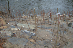
An objective of this and other similar projects designed by the County is to use natural materials to stabilize stream and river embankments, whether these are field rocks and boulders or native plants. In some cases, the velocity and volume of water flowing in stream and river channels is too great and “harder” structural elements are needed. But due to the strength provided by plant roots, as well as the environmental benefits of vegetation, native plants are employed in bank stabilization projects as much as possible; in some cases, they are used exclusively.
To View the Site: The site is best viewed from the paved pedestrian path in the Bronx River Parkway Reservation. The site is next to the Popham Road Bridge, which takes the road over the river and Bronx River Parkway, in Scarsdale.
 One of the largest wetlands in the Bronx River Parkway Reservation has been restored. The 2.5-acre wetland sits next to Fisher Lane in Greenburgh. Decades of change around it had physically isolated the wetland. The Bronx River Parkway and Fisher Lane were built on fill along the west and south sides of the wetland, respectively. An asphalt-paved path, also sitting on a bed of fill, runs along the wetland’s east side. A few pipes underneath the path that once marginally connected the wetland to the waters of the adjacent Bronx River filled with sediment. They partially collapsed and no longer operated. An extension of the wetland to the north had been mowed for years and became more of a wet lawn than a characteristic wetland.
These changes limited the amount of surface water getting into the wetland to a few drainage pipes from the roads. Water sporadically got into the wetland when the Bronx River flooded and its channel could get over the raised path, but this occurred too infrequently. These restrictions reduced the wetland’s ability to improve water quality and absorb floodwaters, both hallmarks of healthy wetlands. More pristine wetlands are known for their ability to act as natural filters and sponges by treating stormwater and the pollution it carries.
The county implemented its plan to restore the wetland beginning in 2013, The county eradicated invasive and dominant reeds (a.k.a., Phragmites), non-native rose, knotweed and various vines that thrived in the wetland due to changes in the wetland’s surroundings. After these plants were removed, three new and larger pipes under the path connecting the wetland to the river were installed. Shallow channels and depressions were created to better manage stormwater entering and exiting the wetland, thereby enhancing the wetland’s ability to improve water quality and absorb stormwater. Habitat diversity has been significantly enhanced. The wetland and stream banks were planted with thousands of native plants in 2014.
To View the Site: The site is best viewed from the paved pedestrian path running through the Bronx River Parkway Reservation. The site is next to Fisher Lane, immediately north of the North White Plains Train Station, off the Bronx River Parkway in Greenburgh.
 Carpenter’s Pond sits on the Sheldrake River north of Sheldrake Lake (Larchmont Reservoir) in the City of New Rochelle. It is surrounded by city parkland. The pond has been created by a dam across the Sheldrake River, causing the river to back up directly behind it and create a long, narrow water body. The sides of the pond consist of moderately sloping woodland. Over the years, as the headwaters of the Sheldrake River drained into the pond, sediment and leaves settled out of the calmer river waters behind the dam. Sediment and leaves filled much of the pond, providing room in some areas for just the river channel. Finally, invasive plants began to dominate the deposits of sediment and leaves. Japanese knotweed was dominant among these plants. In addition to losing its functional value, the pond had became an eyesore.
Construction began in February 2009 and was completed in October 2009. Funded by a state Clean Water/Clean Air Bond Act grant from the Department of State, as well as matching funds from the County of Westchester, City of New Rochelle and Town of Mamaroneck, the project is primarily aimed at restoring the ecological and water quality protection benefits once provided by the pond. The project also allows additional water storage behind the dam during significant storms, thereby providing an ancillary flood control benefit to the City of New Rochelle.
A corroded valve in the existing dam has been replaced under the project. The new valve enables city staff to partially drain the pond prior to storms, thereby increasing the pond’s flood water storage capacity. Excavation to a depth of approximately four feet provides room for this storage, with the sediment being relocated and deposited atop an existing peninsula jutting into the pond. The peninsula consists of accumulated sediment. A large sediment basin at the point where the river enters the pond provides long-term sediment trapping capabilities before the sediment is allowed to settle out in the pond itself. Maintenance vehicles are able to reach the basin via a new, rock-lined accessway.
The project also involved exotic (non-native) and/or invasive plants removal. The peninsula was largely covered by Japanese knotweed, which was removed. It was re-seeded with native grasses. An earthen “shelf” or “bench,” slightly submerged, has been created along the pond’s eastern shore. It has been planted with aquatic and wetland vegetation. The neighboring woodland also was enhanced with native shrubs and trees.
To View The Site: The site is accessible from the end of Daisy Farms Drive, which is accessed via Weaver Street from the east or Wilmot Road from the west. Parking is very limited.
 The Westchester County Center, a community center that hosts conferences, indoor athletic events, theatrical productions and trade shows, receives thousands of visitors each month. Many of them park in the center’s 9.8-acre parking lot on the opposite side of the Bronx River Parkway and Bronx River. So when the County decided to reconstruct the parking lot and needed to treat storm water runoff as part of the project per state and federal regulations, the decision was made to showcase a variety of storm water management practices at the lot.
The resulting storm water management park, all within the County-owned Bronx River Parkway Reservation, is a public educational resource that has been designed to demonstrate how and where storm water management practices can be used to  control storm water pollution. The new parking lot is farther from the river than its predecessor, allowing a planted buffer to be established between it and the river. A new paved pedestrian path runs through the buffer, allowing people closer access to the river. The practices treat storm water runoff to improve water quality and absorb and store the water before it enters the river. They include grass swale medians, notches in curbs so storm water running off the parking lot can get into the swales, storm water ponds and wetlands with native plants, and porous pavement. Other practices include underground storm water storage and infiltration structures and specialized catch basins with embossed educational messages.
 Arched bridges with rock veneer and culverts with stone headwalls were installed to carry pedestrians over the ponds and wetlands and maintain the ambiance of the 1920s Bronx River Parkway. Wooden lamp posts also recall the era when the Bronx River Parkway Reservation was first opened to the public. Educational signs will be installed at the site in 2012, after the segment of river running parallel to the parking lot is restored.
To View The Site: The site is directly opposite the Bronx River Parkway’s intersection (Exit 22) with NYS Route 119 (Tarrytown Road) and NYS Route 100 (Central Avenue), and bounded to the east by the Metro-North Commuter Railroad’s Harlem Line. It is located within the Bronx River Parkway Reservation at the Westchester County Center.
 A section of the Mamaroneck River, sandwiched between Maple Moor Golf Course and Hutchinson River Parkway in White Plains, was restored by transforming a former irrigation pond - degraded by years of sediment accumulation, trash and invasive plants – into viable wetland, riverine and floodplain habitats. These offer both water quality and fish and wildlife habitat improvements.
A newly constructed, elevated berm has split the former pond lengthwise, directing the river's main channel to run along the east bank and enabling the establishment of freshwater wetland (marsh), floodplain and streamside buffer habitats along the west bank. The Hutchinson River Parkway is east of the river and Maple Moor Golf Course is west of it. In-river structures made from boulders further direct channel flows, sending the base flow through the main channel and flood flow through the wetland and floodplain. Excavation and structural work was completed in April 2009 and planting was largely completed in June 2009.
Original restoration plans considered returning the pond to its former stature and installing a basin where the river meets the pond to collect and trap sediment to lessen the degree of further sedimentation. However, this was determined to be infeasible due to the high volume and velocity of water flow during storms. This would continually scour out the basin and quickly fill the pond in again with sediment. The project was then modified to create a two-channel system - one side containing a marsh capable of filtering stormwater runoff coming from the neighboring golf course and accommodating flood waters during storms; the other side containing the river channel and its typical water flows. The two sides are separated by the earthen berm, which consists of excavated sediment taken from the former pond.
 The marsh and other wetlands at the water’s edge consist of aquatic perennials, such as arrowhead, bulrush and iris. The streamside buffer consists of native grasses, shrubs and a few trees. The berm has been planted with wetland perennials and a few trees tolerant of floodplain conditions. All of these habitats will help filter out pollutants and nutrients found in stormwater runoff from the parkway and golf course and provide shelter for fish and wildlife. The project also will help the river to flow more efficiently, thereby lessening impacts from flooding.
To View the Site: Maple Moor Golf Course is located off of Route 127 (North Street) between the Hutchinson River Parkway and McGuiness Lane. The site is along the eastern edge of the golf course next to the Hutchinson River Parkway. Due to golf play, permission is needed from golf course staff or the Department of Parks, Recreation and Conservation to visit the site.